Fire Incident Links

1. Fire maps and details
The link below maps all wildfires and emergencies.
https://www.emergency.vic.gov.au/respond/
Local Stubble and Planned CFA burns
If you see smoke on a calm day it might be a stubble burn
Click here for a map of progress of all planned CFA burns in Victoria
Click here to see the latest list of local stubble burns
2. Prepare for a fire: How to get ready
2.1 Lismore CFA Brigade facebook page hopes to keep locals up to date with preparations for a local fire. (But no guarantees, and follow the CFA and EMV sites!)
2.2 CFA Public information home page. The official source.
www.cfa.vic.gov.au/home
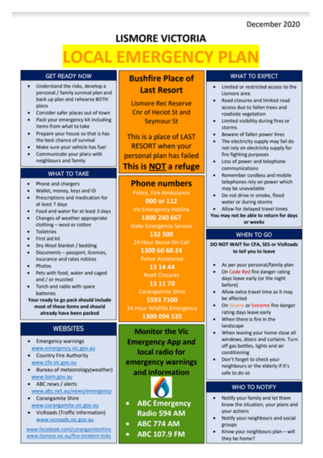
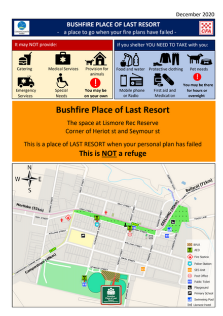
2.3 Lismore Emergency Plan Designed for our town by our people. (A copy is at the bottom of this page)
Click here to download the latest version.
Shire Strategic Fire management Plan gives
2.4 CFA Plan and prepare pages. Lots of good tips. PREPARE EARLY!
https://www.cfa.vic.gov.au/plan-prepare
2.5 Leave early or stay and defend?
Click here to help decide. Gripping Four Corners program "Black Summer" 49 mins.
3. Weather: Now, and into the future.
3.1 Official weather. Mortlake aerodrome. Official Bureau of Meteorology 1/2 hour data here.
www.bom.gov.au/products/IDV60801/IDV60801.94840.shtml
3.2 Weatherzone gives figures now and predicts the future weather for 7 days.
www.weatherzone.com.au/vic/south-west/lismore
3.3 A norwegian weather site does the same for 9 days, or by the hour.
https://www.yr.no/place/Australia/Victoria/Mortlake/
3.4 Windy give lots of information including lightning strikes. Very versatile. Explore....
https://www.windy.com/-Show---add-more-layers/overlays?temp,-37.645,143.873,9
3.5 Meteye gives wind and temperature into the future. Simpler than Windy.
www.bom.gov.au/australia/meteye/?loc=TAS_FA001
4. What is happening? Fire radio
4.1 The official fire updates are ABC 594 AM, ABC 774 AM, ABC FM 107.9 FM, ACE 1134 AM.
www.abc.net.au/news/emergency
4.2 EMV information page. Has official media releases, warnings. Mapping may be delayed.
http://emergency.vic.gov.au/respond/
Phone app: Vic Emergency. Ditto. Download it now and set it up.
4.4 Vicroads (works and closures) https://traffic.vicroads.vic.gov.au/
4.5 Listen to emergency callout radio live. Plays callout channels, (not fireground channels).
www.broadcastify.com/listen/feed/19010
Phone app: Broadcastify. (This uses lots of data so you need an unlimited phone plan)
5. Social Media:
5.1 EMV facebook. Official releases. They may start a separate page for a big fire.
https://www.facebook.com/vicemergency/
5.2 EMV twitter. Official releases. Continually updated with links and maps.
https://twitter.com/vicemergency/
5.3 Corangamite Shire facebook. Very good for the recovery stage of a fire.
https://www.facebook.com/CorangamiteShire/
5.4 Shire twitter page. May be useful for the tweets from the public.
twitter.com/corangamitesc
5.5 Lismore CFA Group facebook. Not official. May have faster information, and from several sources.
https://www.facebook.com/CFALismoreGroup1
5.6 Mount Elephant firecam facebook. Photos of local fires from the summit.
Not official. May be delayed.
https://www.facebook.com/Firecam-Mount-Elephant-287240355457384/
6. Eye in the Sky.
Satellite tracking: Maybe 12 hrs delay. Shows the hot spots around the world.
6.1 NASA EODIS worldview. Can select which satellites to use. maybe 12 hrs delay.
worldview.earthdata.nasa.gov/
6.2 NASA FIRMS (Fire Information Resource Tracking System) Very versatile. Explore it.
firms.modaps.eosdis.nasa.gov/
6.3 Firewatch hotspots (Simple to use. Maybe 12 hours delay. )
https://myfirewatch.landgate.wa.gov.au/map.html
6.4 Sentinel hotspots. Simple. Maybe 12 hrs delay, but accurate.
https://hotspots.dea.ga.gov.au/acres/sentinel/kml_data.shtml
7. Behaviour Prediction: and what to do.
How dangerous? (On a bad day a grassfire may travel at 8 - 10 km per hour, with flames about 3 times the height of the fuel. Travels faster uphill than downhill).
New Fire Danger Rating System: Click here for the details
How dangerous? (On a bad day a grassfire may travel at 8 - 10 km per hour, with flames about 3 times the height of the fuel. Travels faster uphill than downhill).
New Fire Danger Rating System: Click here for the details
8. Phone Numbers
Police, Fire , Ambulance. 000 or 112
(You will be asked for the street number and nearest cross-street. Also your phone number).
Vic Emergency Hotline 1800 240 667
State Emergency Service 132 500
24 Hour Nurse On Call 1300 606 024
Police Assistance 13 14 44
Road Closures 13 11 70 (business hours)
Corangamite Shire 55937 100
9. Share this page.
Scan the QR code below to save it to your smart phone.
(Older phones may need a QR reader App) (This is not the COVID App)
Scan the QR code below to save it to your smart phone.
(Older phones may need a QR reader App) (This is not the COVID App)


